It used to be that staying on Route 66 was easy — just follow the official highway road signs west. However, ever since the historic route was officially decertified by the U.S. government, things have gotten a little more complicated. Even with the GPS mapping technology on your smartphone, playing a Route 66 road trip “by ear” probably isn’t the best call. By planning ahead, you can ensure that you stay on the Mother Road and witness all of the sites and landscapes you’re most excited to see.
Why can’t I just follow Route 66 road signage?
Look on an updated road map and you won’t find Route 66 listed among the highways, state routes and interstates that crisscross the American West. Since 1984, the “Mother Road,” as John Steinbeck once referred to it in his famous novel “The Grapes of Wrath,” has been totally decommissioned.
Although things are starting to look up, the current road sign situation on Route 66 is spotty at best. In 1999, the U.S. Congress passed the Route 66 Corridor Historic Preservation Act, which established a federally funded preservation program, under the supervision of the National Park Service. Originally set to expire in 2009, the program was extended by Congress for an additional 10 years.
Although congressional aid went a long way towards preserving the Mother Road, others have been just as instrumental. Where the federal government no longer assists, state and local authorities have stepped in to aid travellers and honour the history and legacy of Route 66. The Oklahoma Department of Transportation, for example, invested in 400 new signs, including replacements for their 80 existing ones, at the end of 2020. The signage will indicate that drivers are on roads that were part of the original route, to make staying on the path easier than ever. In addition to clearing up any confusion, officials believe the investment will pay off for small business owners on the road, according to The Oklahoman. Several other states have kept up their Route 66 signage, switching it from federal purview to state historic routes. In addition, many municipalities have created their own signage to signify that they were located along “Old” Route 66.
While the road sign situation across all of Route 66 is still probably not consistent enough to travel without the aid of a programmed GPS or an accurate road atlas, the swell of support for restoration shows that Mother Road will continue to be there for explorers in the years to come.
Tools for mapping out the ultimate road trip
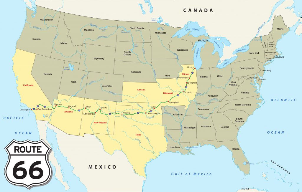
While the challenges of today’s Route 66 can sometimes make the journey from Chicago to the Santa Monica pier in Los Angeles a challenging one, the right atlas or a specially programmed GPS can make it possible to follow the original route from start to finish without issue.
There are multiple road atlases designed for the Route 66 adventurer. These will show which roads to travel on and give context to the surrounding area. While atlases that span the entire Mother Road are out there, many are available in region-by-region volumes. In addition to the right maps, it’s highly advisable to bring along a specialised guidebook. These can alert you to any knowledge about road conditions (as some parts of historic Route 66 are maintained better than others) and seasonal closures to help ensure you have the best possible trip.
While you won’t be able to simply plug “Route 66” into Google Maps, Apple Maps or other similar apps, specialty GPS programs that can offer a step-by-step approach are out there. In addition, GPS mapping can help you ensure that you’re on the road you think you are and help you retrace your steps if you end up going astray.
With mapping apps making it possible to optimise every turn of a drive these days, the “work for it” nature of a Route 66 road trip can be a refreshing change of pace with the right attitude. Of course if periodically checking a road atlas isn’t what you have in mind for your holiday, working with an experienced tour guide could be the right call for you.
How Route 66’s path came to be
Even before it was decommissioned, a drive down Route 66 could be a complex undertaking. Compared to an interstate highway, Route 66 follows a seemingly winding path. It was actually designed that way. In 1926, the U.S. Department of Transportation, acting on a recently passed law in the U.S. Congress, commissioned Route 66 with the explicit purpose of connecting the rural communities of the American West with major metropolitan areas like Chicago, St. Louis, Tulsa, Oklahoma City and Los Angeles. To achieve this goal, designers tried to run the road through as many small towns as possible, while taking a relatively direct path. This decision helped make new growth in the region possible and today is responsible for the authentic, small town feel that permeates across the drive.
While the construction of Route 66 quickly opened up new opportunities and development potential across the American west, it soon wasn’t enough. In the 1940s and 1950s, the U.S. population expanded rapidly, both from new immigration and the post-World War II “baby boom.” Many of these new residents and families settled along the plains, deserts and mountains around Route 66. With a denser population and ballooning car ownership, many of the routes created in the 1920s and 1930s quickly became insufficient to handle growing traffic, including Route 66.
In 1956, President Dwight D. Eisenhower signed the Federal-Aid Highway Act, establishing the construction of a new, larger system of roads, called the National System of Interstate and Defence Highways. New developments, like Interstate 40 — stretching from Oklahoma City to southern California — and I-55 in Missouri, Oklahoma and Texas, covered much of the same territory as historic Route 66. With faster ways to get from point A to point B, the historic road fell into disuse and was slowly decommissioned over the ensuing decades.
See the Mother Road with Route 66 Tours
There’s no better way to see America than through a route 66 road trip, and no better company to do it with than Route 66 Tours. Our trips take all the guesswork out of following the historic route and ensure a quality holiday where you see exactly what you set out to.
Whether you choose to drive yourself or let one of our experienced Aussie guides take the wheel, you’ll never have to worry about straying from the path (unless, of course, there’s an attraction you want to see that’s a little farther afield, like the Grand Canyon). Each of our “fully guided” cars comes equipped with a programmed GPS, a fantastic guide book and a road atlas. Of course, you won’t really need them as our guides know exactly where they’re going.
By keeping the tours self-driving and personalised, our Route 66 tour clients have the flexibility to travel their way. You can look forward to an incredible 20 nights trip from Chicago to Las Vegas, exploring the best antique cars, roadside attractions, historic places and natural features that America has to offer. For more information on our next planned adventure, go to www.route66tours.com.au.